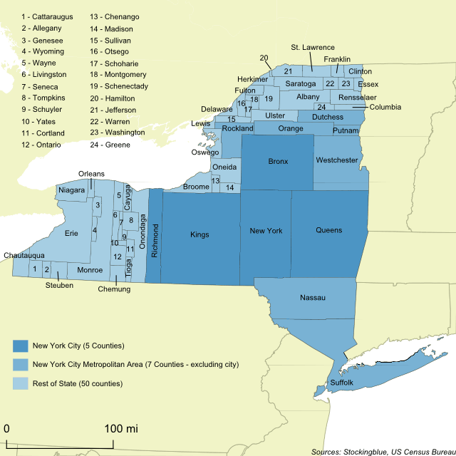
The geographically accurate cartogram above represents the size of the counties based on their population. New York City makes up nearly half (42.19%) of the state's population and thus takes up a much larger portion of the state's landmass than it currently does.
Findings
- Kings County has the largest population in the state. It alone is responsible for just over one out of every ten people in the state.
- Hamilton County has the smallest population and accounts for 0.02% of the state's total population.
- Six counties (Kings, Queens, New York, Suffolk, Bronx, and Nassau) are responsible for just over half the population.
- Outside the New York City Metropolitan Area, Erie County has the largest population at just under 1 million.
Caveats
- The data is from 2010.
- The borders represent the area of the state if it were based on the number of people. The larger the county, the more people it has.
- The map is presented in a North American Datum of 1983 projection.
Details
The city combined with its metropolitan area take up 74.90% of the state's area leaving just slightly over a quarter of the state for the remaining counties.
The total population of the state is 19,378,102.
Data
| County | Population | Percent of State Population |
|---|---|---|
| Kings | 2,504,700 | 12.93 |
| Queens | 2,230,722 | 11.51 |
| New York | 1,585,873 | 8.18 |
| Suffolk | 1,493,350 | 7.71 |
| Bronx | 1,385,108 | 7.15 |
| Nassau | 1,339,532 | 6.91 |
| Westchester | 949,113 | 4.90 |
| Erie | 919,040 | 4.74 |
| Monroe | 744,344 | 3.84 |
| Richmond | 468,730 | 2.42 |
| Onondaga | 467,026 | 2.41 |
| Orange | 372,813 | 1.92 |
| Rockland | 311,687 | 1.61 |
| Albany | 304,204 | 1.57 |
| Dutchess | 297,488 | 1.54 |
| Oneida | 234,878 | 1.21 |
| Saratoga | 219,607 | 1.13 |
| Niagara | 216,469 | 1.12 |
| Broome | 200,600 | 1.04 |
| Ulster | 182,493 | 0.94 |
| Rensselaer | 159,429 | 0.82 |
| Schenectady | 154,727 | 0.80 |
| Chautauqua | 134,905 | 0.70 |
| Oswego | 122,109 | 0.63 |
| Jefferson | 116,229 | 0.60 |
| St. Lawrence | 111,944 | 0.58 |
| Ontario | 107,931 | 0.56 |
| Tompkins | 101,564 | 0.52 |
| Putnam | 99,710 | 0.51 |
| Steuben | 98,990 | 0.51 |
| Wayne | 93,772 | 0.48 |
| Chemung | 88,830 | 0.46 |
| Clinton | 82,128 | 0.42 |
| Cattaraugus | 80,317 | 0.41 |
| Cayuga | 80,026 | 0.41 |
| Sullivan | 77,547 | 0.40 |
| Madison | 73,442 | 0.38 |
| Warren | 65,707 | 0.34 |
| Livingston | 65,393 | 0.34 |
| Herkimer | 64,519 | 0.33 |
| Washington | 63,216 | 0.33 |
| Columbia | 63,096 | 0.33 |
| Otsego | 62,259 | 0.32 |
| Genesee | 60,079 | 0.31 |
| Fulton | 55,531 | 0.29 |
| Franklin | 51,599 | 0.27 |
| Tioga | 51,125 | 0.26 |
| Chenango | 50,477 | 0.26 |
| Montgomery | 50,219 | 0.26 |
| Cortland | 49,336 | 0.25 |
| Greene | 49,221 | 0.25 |
| Allegany | 48,946 | 0.25 |
| Delaware | 47,980 | 0.25 |
| Orleans | 42,883 | 0.22 |
| Wyoming | 42,155 | 0.22 |
| Essex | 39,370 | 0.20 |
| Seneca | 35,251 | 0.18 |
| Schoharie | 32,749 | 0.17 |
| Lewis | 27,087 | 0.14 |
| Yates | 25,348 | 0.13 |
| Schuyler | 18,343 | 0.09 |
| Hamilton | 4,836 | 0.02 |
Sources
United States Census Bureau. "Annual Estimates of the Resident Population: April 1, 2010 to July 1, 2016." Accessed December 12, 2017. http://factfinder2.census.gov.