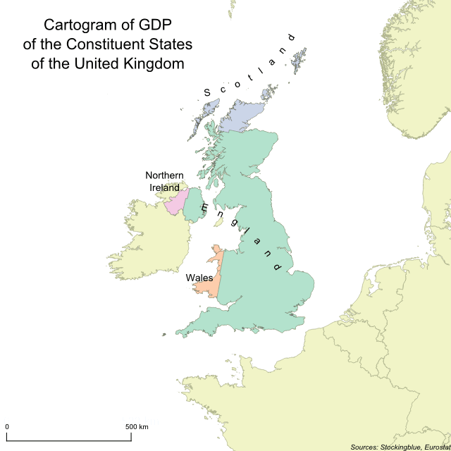
In this geographically accurate cartogram, the constituent states of the United Kingdom are redrawn according to their gross domestic product (GDP). England is the only state to gain territory at the expense of the other three and it gains more territory than it did when borders were redrawn for population.
Findings
- England has the largest GDP, and thus claims the largest amount of territory.
- Scotland, Northern Ireland, and Wales all lose territory.
- England makes up over 85 percent of the total GDP of the United Kingdom.
Caveats
- GDP data is from 2017.
- The map is presented in an Albers equal-area conic projection.
Details
In absolute terms, England gains the most territory adding over 80,000 square kilometers while Scotland loses the most ceding over 60,000 square kilometers.
In relative terms, England gains the most territory gaining 62.79% more land. Scotland loses the most territory ceding 76.35% of its land.
Northern Ireland loses over three-fifths of its territory while Wales loses just under three-fifths.
England is the largest state geographically as well as economically. Conversely, Northern Ireland remains the smallest state as it is both smallest geographically and economically.
The total GDP of the United Kingdom is €2,316,114 million.
Data
| State | GDP (in euros) |
|---|---|
| England | 2,007,707.19 |
| Northern Ireland | 50,888.58 |
| Scotland | 177,621.16 |
| Wales | 79,897.47 |
Sources
Eurostat. 2019. "Gross Domestic Product (GDP) at Current Market Prices by NUTS 2 Regions." Accessed October 31, 2019. https://appsso.eurostat.ec.europa.eu/nui/show.do?query=BOOKMARK_DS-513634_QID_2C6D709_UID_-3F171EB0&layout=TIME,C,X,0;GEO,L,Y,0;UNIT,L,Z,0;INDICATORS,C,Z,1;&zSelection=DS-513634INDICATORS,OBS_FLAG;DS-513634UNIT,MIO_EUR;&rankName1=UNIT_1_2_-1_2&rankName2=INDICATORS_1_2_-1_2&rankName3=TIME_1_0_0_0&rankName4=GEO_1_2_0_1&sortC=ASC_-1_FIRST&rStp=&cStp=&rDCh=&cDCh=&rDM=true&cDM=true&footnes=false&empty=false&wai=false&time_mode=NONE&time_most_recent=false&lang=EN&cfo=%23%23%23%2C%23%23%23.%23%23%23